Top 10 Mountains in Kenya and their Counties
Ask ten Kenyans to name a mountain and nine will say Mount Kenya before you've even finished the question. Fair enough, it's the second highest peak in Africa and it dominates the skyline for half the country. But Kenya isn't a one-mountain nation. It's a landscape stitched together by volcanic ridges, fault-block plateaus, and old shield volcanoes that stretch from the shores of Lake Turkana down to the coastal plains near Tanzania. Each one sits inside specific counties, shapes the local climate, feeds rivers that entire communities depend on, and offers a completely different climbing experience depending on where you stand.
This guide walks through ten of the major mountains in Kenya, the counties they belong to, and what actually makes each one worth knowing, whether you're planning a climb or just trying to understand how the country's geography fits together.
Mount Kenya Sits Across Five Counties
Mount Kenya isn't tucked inside one administrative boundary, it sprawls across five counties, and that's part of why it dominates the national conversation on geography, water, and tourism. The Mount Kenya National Park overview lists the twin peaks of Batian at 5,199 metres and Nelion at 5,188 metres as the highest points, with Point Lenana, at 4,984 metres, being the one most trekkers actually reach since it doesn't demand technical climbing skills. The mountain is an extinct stratovolcano, its jagged summits are what remains of a much taller cone that eroded over roughly three million years. There are still small glaciers clinging to the upper slopes, though they're retreating fast, and the vegetation zones shift dramatically as you climb, from montane forest to bamboo to moorland scattered with giant lobelias and groundsels that look like they belong on another planet entirely.
Meru
On the northeastern side, Meru County holds some of the wildest, least crowded slopes of the mountain. This is where the Chogoria route begins its ascent, and honestly, if you want scenery without the crowds, this county delivers it.
Tharaka Nithi
Tharaka Nithi shares that eastern flank and blends into the lower forest zones where local subspecies of colobus monkeys and forest antelope move through the canopy. It's drier here than the western side, and the transition into savannah is noticeably quicker.
Embu
Embu County wraps around the southeastern slopes, an area historically tied to coffee and tea farming that thrives because of the volcanic soils washed down from the mountain over thousands of years.
Kirinyaga
Kirinyaga sits directly south, and this is one of the zones scholars point to when discussing tourism disparities. Commercial investment and conservation funding tend to cluster more heavily around the western and southern approaches than the remote northern slopes, a pattern documented in research on alpine tourism dynamics in the Mount Kenya region.
Nyeri
Nyeri County anchors the western side and functions as the main gateway for climbers using the Naro Moru route. Nanyuki, just outside the county but tightly linked to Mount Kenya tourism, sits near the equator line and serves as a logistics hub for guides, gear rental, and acclimatization stops.
Mount Elgon Rises On The Uganda Border
Mount Elgon is a different beast altogether, a massive extinct volcano straddling the Kenya Uganda border, and one of the largest volcanic bases in Africa by surface area. Standing at 4,222 metres, according to the KWS Mount Elgon National Park portal, it features caves carved by elephants seeking salt deposits, sweeping heathlands, and endemic flora found almost nowhere else on the continent.
Bungoma
Bungoma County covers the Kenyan southern approach, where the terrain rises gradually through farmland before hitting forest reserve boundaries.
Trans Nzoia
Trans Nzoia holds the more commonly climbed western slopes, with Kitale acting as the jumping-off point for most travelers attempting the summit.
The Aberdare Range Spans Four Central Provinces Counties
The Aberdare Range is often overshadowed by Mount Kenya, which is a shame because it holds its own kind of drama, misty ridgelines, dense bamboo forest, and Karuru Falls plunging 273 metres, the tallest waterfall in the country according to the Aberdare National Park guide. Mount Satima, the highest point in the range, reaches 4,001 metres.
Nyeri
Nyeri appears again here, on the eastern edge of the Aberdares, linking the range geographically to Mount Kenya through a corridor of highland forest.
Nyandarua
Nyandarua County takes its name from the range itself and covers the western slopes, where the terrain is colder and wetter than most people expect from equatorial Africa.
Murang'a
Murang'a sits to the south, an area dense with tea plantations fed by streams originating from the range's forested catchments.
Kiambu
Kiambu closes out the four, and its proximity to the capital Nairobi means this section sees far more day-trip traffic than the others.
The Cherangany Hills Cross The North Rift
The Cherangany Hills don't get nearly the attention they deserve. This is a fault-block upland plateau spanning roughly 95,600 hectares, according to the Key Biodiversity Areas factsheet, reaching 3,365 metres at Cheptoket Peak. It's one of Kenya's five major water towers, feeding rivers that flow into Lake Turkana and the Nile basin.
Elgeyo Marakwet
This county holds much of the eastern escarpment, dramatic cliffs dropping into the Kerio Valley below.
West Pokot
West Pokot covers the northern reaches, an area still relatively undocumented in mainstream trekking circles.
Trans Nzoia
Trans Nzoia appears here too, overlapping slightly with its Mount Elgon boundary, which tells you something about how tightly packed western Kenya's highlands actually are.
Mount Longonot Marks The Great Rift Valley
Mount Longonot is a dormant stratovolcano sitting inside a 52 square kilometre national park, according to the KWS Mount Longonot profile. Its crater holds a thick forest interior, and the rim trail offers some of the best panoramic views of the Rift Valley floor you'll find anywhere in the country.
Nakuru
Nakuru County hosts the entire mountain, and its position near Lake Naivasha makes it a popular half-day add-on for travelers already exploring the Rift.
The Ngong Hills Overlook Nairobi And Kajiado
The Ngong Hills form a ridge of rolling volcanic hills, famous partly through literature and partly through the wind turbines now lining the ridge, part of East Africa's pioneering 25.5 MW wind power installation.
Kajiado
Kajiado County holds most of the ridge and the wind farm infrastructure itself.
Nairobi
The capital Nairobi borders the hills closely enough that on a clear day, the skyline and the ridge share the same horizon, a rare thing for a capital city anywhere in Africa.
Mount Marsabit Rises From Northern Kenya's Desert
Mount Marsabit is essentially a green island in a sea of desert, a forested volcanic massif that creates its own microclimate in one of the driest parts of the country.
Marsabit
Marsabit County surrounds the mountain entirely, and the contrast between the arid plains below and the misty forest above is genuinely disorienting the first time you see it.
The Taita Hills Break Up The Coastal Plains
The Taita Hills rise unexpectedly out of the flat coastal plains, an ancient Precambrian block that predates most of Kenya's volcanic ranges by millions of years.
Taita Taveta
Taita Taveta County holds the entire range, and its cooler slopes have historically supported agriculture that wouldn't survive in the surrounding lowland heat.
Mount Suswa Hides A Volcanic Caldera
Mount Suswa is one of the stranger geological formations in the country, a shield volcano with a double caldera structure and an extensive network of lava tunnels, detailed in a technical geological analysis of Suswa's caldera. It reaches 2,356 metres.
Narok
The northwestern section of the mountain falls within Narok County, while the eastern slopes cross into Kajiado, according to the Wikipedia entry on Mount Suswa.
Mount Kulal Guards The Shores Of Lake Turkana
Mount Kulal rises sharply near the eastern shore of Lake Turkana, a fractured volcanic massif that creates its own forest belt in an otherwise scorched landscape.
Marsabit
Marsabit County claims this mountain too, which makes it the county with arguably the widest range of terrain in the entire country, from lakeside desert to misty highland forest within a single jurisdiction.
How Do These Mountains Compare In Altitude?
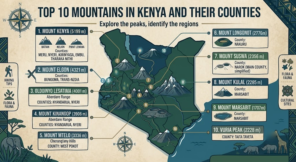
Mountain | County(ies) | Peak Altitude |
|---|---|---|
Mount Kenya | Meru, Tharaka Nithi, Embu, Kirinyaga, Nyeri | 5,199 m (Batian) |
Mount Elgon | Bungoma, Trans Nzoia | 4,222 m |
Aberdare Range | Nyeri, Nyandarua, Murang'a, Kiambu | 4,001 m (Mount Satima) |
Cherangany Hills | Elgeyo Marakwet, West Pokot, Trans Nzoia | 3,365 m (Cheptoket Peak) |
Mount Marsabit | Marsabit | approx. 1,700 m |
Mount Suswa | Narok, Kajiado | 2,356 m |
Mount Longonot | Nakuru | 2,776 m |
Menengai Crater | Nakuru | 2,278 m |
Ngong Hills | Kajiado, Nairobi | approx. 2,460 m |
Taita Hills | Taita Taveta | approx. 2,208 m |
Which Mount Kenya Route Should You Choose?
Choosing a route depends entirely on what kind of mountain experience you actually want, because the three main options offer wildly different pace, scenery, and difficulty.
Sirimon Route
Sirimon approaches from the northwest and is generally considered the driest and gentlest ascent, making it a favourite for climbers prioritizing acclimatization over drama.
Chogoria Route
Chogoria, starting in Tharaka Nithi, is widely regarded as the most scenic route in the entire range, cutting through the Gorges Valley with views that genuinely rival anything else on the continent. Many guides recommend the Chogoria traverse, ascending one route and descending another, as the single best way to experience the mountain's full range of ecosystems.
Naro Moru Route
Naro Moru is the shortest and steepest option, which sounds appealing until you're standing at the infamous "vertical bog" section wondering why you didn't choose Sirimon instead.
When Is The Best Time To Climb Mount Kenya?
The driest climbing periods fall between January and February, and again in August through September, when rainfall drops and the trails firm up considerably. Outside these windows, the moorland sections turn to thick mud and visibility on the summit approach drops fast.
Do You Need A Guide To Climb Kenya's Mountains?
Yes, and not just for safety. Kenya Wildlife Service and county forest authorities generally require registered guides for park entry, and beyond the paperwork, local guides read weather shifts and altitude symptoms in climbers far quicker than a first-timer ever could on their own.
How Should You Prepare For Altitude And Fitness?
Altitude is the main challenge, not distance. Point Lenana sits well above 4,900 metres, and the standard three to five day itineraries are built specifically around acclimatization, not just fitness. A slower pace with proper rest days at intermediate huts matters more than raw cardio conditioning, and travelers who ignore that tend to turn back within sight of the summit.
What Should You Pack For A Mountain Climb In Kenya?
Layered clothing for temperature swings between forest zones and the alpine summit
Waterproof boots suited to muddy moorland sections
A sleeping bag rated for sub-zero nights at altitude
Basic altitude sickness medication after consulting a doctor
Headlamp for early morning summit pushes
FAQ
Which is the highest mountain in Kenya? Mount Kenya, with Batian peak reaching 5,199 metres.
Can beginners climb Mount Kenya? Yes, reaching Point Lenana requires no technical climbing skills, just decent fitness and proper acclimatization.
Which county has the most mountain diversity? Marsabit, spanning both Mount Marsabit's forest and Mount Kulal's highland belt near Lake Turkana.
Conclusion
Kenya's mountains aren't just scenery, they're water sources, county boundaries, farming belts, and in some cases, entire microclimates holding back the desert. Understanding which county each one belongs to isn't trivia, it's the groundwork for planning any real climb, any research trip, or honestly, just making sense of how the country's geography actually holds together across regions that otherwise feel worlds apart.